There are two main sources of maps of Tudor London: Agas map and the Civitates Orbis Terrarum map (Civitates map for short).
The Agas map
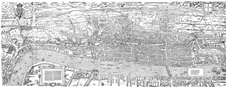
The Agas map is a large map made from wood blocks. The Agas map dates somewhere probably between 1561 and 1571. The Agas map is the bigger of the two at about two metres in length. It was made up of eight wood blocks. Woodblock engraving is a cruder than that of engraving on metal. Metal engraving is much more expensive and the plates last a lot longer.
One of the things that when you see reproductions of the Agas map, you can see the joints between the woodblocks, so in that respect, the Agas map is a little bit crude.
The Agas map isn’t by Agas and it isn’t a map. This is the kind of thing that historians love talking about. Agas was a surveyor in the reign of Elizabeth and the map was for a long time attributed to him, but it the, yeah it wasn’t by him and it’s not really a map cuz it’s done as a kind of view from an angle looking down at London.
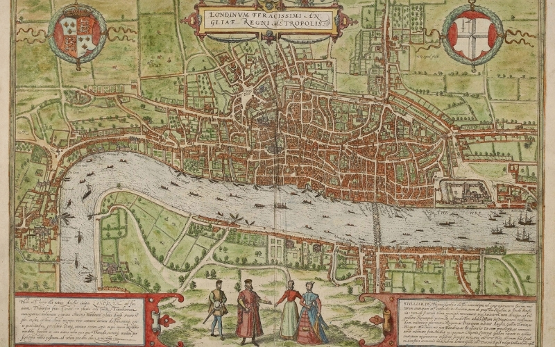
Civitates orbis terrarum. Public Domain Mark 1.0 https://www.bl.uk/collection-items/view-of-london-in-civitates-orbis-terrarum
Civitates Orbis Terrarum
The Civitates Orbis Terrarum is Latin for ‘cities of the world’ and is an atlas first produced in six parts between 1572 and 1617, in Cologne. It was printed in this early 17th-century edition (c. 1600–23) and within its hundreds of maps of cities from around the world. The Civitates map is copperplate. It’s made from two copper plates and formed two leaves within the atlas. You’d open the atlas and you’d have this map of London.
The Civitates map is the one that’s closest to a map in the sense that the view is largely map, the perspective does move around and so is a challenge to get one’s bearings at times.
One interesting feature of both of these Tudor London maps is that they both include the spire of St. Paul’s Cathedral, which was a very notable landmark and which was destroyed by lightning in 1561. They both derive from the same original, which has been partially lost but is hugely important because it’s the first accurate map of London.
Why are the woodblocks and copper plates badly eroded?
They were used a lot for printing and also they’ve been reused. The reason they’ve survived is that people repurposed the plates and used them for making a painting on the other side which is why the three plates have survived. Enough of those plates exist to show that this original map was incredibly expensive to make. We don’t know who paid for it. One theory is that it might well have been produced by Hanseatic merchants in the 1550s who wanted to present an elaborate gift to Philip II, consort of Queen Mary I, lobbying for a renewal of their privileges.
They’re both very accurate in terms of reproducing what was there and therefore they’re extremely interesting and dominant in both, obviously, is the River Thames and you can see details on the river Thames. London Bridge is easy to spot as it’s the only bridge to cross the river at that time. Continuing downriver to the East, you can see the Thames is quite well populated with large sailing ships and then up river from the Thames things change because you’ve got small boats and not sailing ships. And one nice little detail is that obviously deriving from the copper plate map, there’s a little detail of a barge being pulled and that is the royal barge making its way up river.
Listen to what City of London tour guide Ian McDiarmid has to say about maps of Tudor London:
Related Content:
You may enjoy the full podcast episode about The Port of London during the Tudor Period